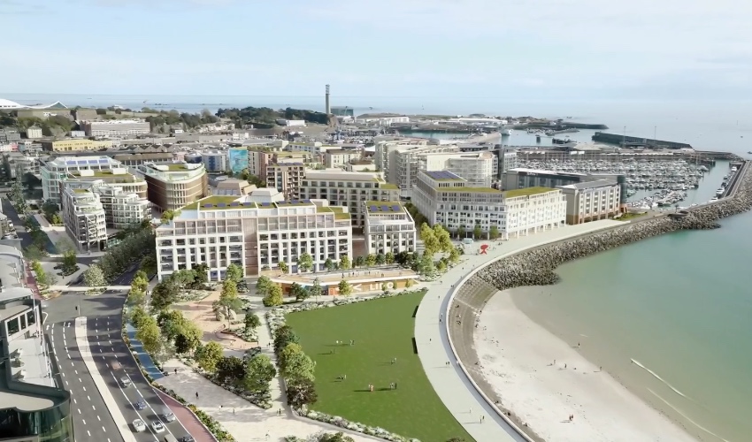
Key reasons for refusal were:
The proposed development would fail to achieve the community expectation of reconnection between St Helier and the Waterfront.
The application provides insufficient improvements to La Route de la Liberation, leaving a largely untamed highway that separates the waterfront from the rest of town.
Taking these two objections, there is an obsession with "joining up" the waterfront to the rest of St Helier which has been an idée fixe since the earliest days of planning.
One solution was a massively expensive sunken road which would continue the underpass until it came up near Gloucester Street, and have (in some versions) an underground roundabout, because of course you have freight lorries coming from the harbour which have to go from there to West or East, and currently go over the top.
There were never any feasible solutions to the issue of ventilation, although the increasing advent of electric vehicles might make that less of an issue, but cost of ventilating, and of probably pumps to keep it dry when there was excessive rainfall, was simply never part of the grand scheme of things.
And no consideration was given to the total disruption to traffic for at least almost a year while the whole scheme went ahead, and we have already seen how traffic disruption through works in the tunnel has a large knock on effect. A crash which put the road by the Old Harbour out of action about a decade ago also showed the dynamics of the traffic in that area - traffic was backed up to Bath Street. The disruption of a sunken road - with no underpass available while construction took place - would be indescribable and probably cause public anger and election suicide for any politician stupid enough to push for it.
The possibility of collapse of the scheme half way through, with the States picking up pieces (as happened with Queen's Valley), weighted heavily on Senator Philip Ozouf's mind so that the developers Harcourt had to stump up a bond to cover that eventuality as insurance. They could not do so, or decided not to do so, and the whole sunken road was put on the back burner.
The CEO of what became the Jersey Development Company (changing it's name from The Waterfront Enterprise Board) decided that the development could go ahead internally under the quango's auspices, self-financing, but not in the order originally planned (with the sunken road first, then partly built upon), which is why the International Finance Centre buildings had numbers which were completely out of order. But this did enable the development to go ahead - as it is still doing so - and the sunken road became a footnote.
An alternative mooted at one point was a bridge over the top, but that didn't get off the ground either. It would have been fine for pedestrians - as long as they were not in wheelchairs or had mobility issues.
But no one has really checked this supposed "community expectation" or this "untamed highway". I have. I have parked for several years in the public car park by the Radisson, and never found any major issues with walking into St Helier on a daily basis. I would suggest just two improvements:
1) the reinstatement of the underground walk way (which also was a roadway) from that car park, currently blocked off because of the new development. Even if not used for cars, as a pedestrian subway it was excellent, and cut my journey time considerably. It really did "join up" the waterfront to the town well. The subway also has the advantage of cutting under the three lane above ground area at that part of the waterfront to town area. It is already there, so if once the building work is done, it could re-open it would be most helpful in improving access..
2) The roundabout area is well served by some zebra crossings, but going from by Cineworld along the outside and over to the harbour is not well served and you have to check as cars can zoom down towards the harbour. A zebra crossing there like the other ones would really improve matters considerably.
The zebra crossings that are there are excellent. Traffic does not rush past over the top, and they provide quick and easy access from the waterfront area to the main town area.
This obsession with linking the two has I think come from those who never have actually on a daily basis come from the waterfront or gone back to it. They have simply looked at a map and decided that it is an "untamed" without ever having "walked the walk".
I have, and I speak from the benefit of experience, not like a Great War general moving troops on a map, which seems to be the way in which thinking on this subject has been conducted.
As someone who did so on a daily basis for around 5 years, I can say categorically "untamed" is not the case. There is room for a few relatively minor improvements (as detailed above) but no need for major extensive, expensive, and ultimately unwanted changes to the road network.


.jpeg)


